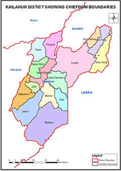
KAILAHUN DISTRICT
Kailahun District is in the Eastern Province of Sierra Leone and Kailahun Town is the district headquarter town. The district borders with Kono and Kenema districts as well as Liberia and Guinea.
Councils: Kailahun District has only one local council, which is headed by a Chairperson and assisted by a Deputy Chairperson. Kailahun district has 29 wards ranging from Ward 001 to 029, that is headed by 29 councillors.
Chiefdoms: Kailahun has 14 Chiefdoms administered by Paramount Chiefs. The 14 Chiefdoms in the district are as follows: Dea; Jaluahun; Jawei; Kissi Kama; Kissi Teng; Kissi Tongi; Lawa; Malema; Mandu; Peje Bongre; Peje West; Penguia; Upper Bambara; Yawei.
Constituencies: Kailahun District has 10 Constituencies ranging from Constituency 001 to 010
Ethnicity: The population of Kailahun district is largely from the Mende tribe, with Kissi, Kono, Sherbro and Vai being the minority ethnic groups.
Economic Activities: Kailahun has a mixed economy with small-scale mining and agricultural production of coffee, cacao and rice.
Education: Kailahun District has 523 schools: 52 Pre-primary Schools; 396 Primary Schools; 56 Junior Secondary Schools and 19 Senior Secondary Schools.
Population:
Name |
Status |
Population
Census
2004 |
Population
Census
2015 |
Population
census
2021 |
Kailahun |
District |
358,190 |
526,379 |
545,947 |
KAILAHUN DISTRICT SHOWING CHIEFDOM BOUNDARIES
COUNCIL HEAD |
Sahr K. Lamin
Chairperson
Kailahun District Council
Chief Administrator:
+23278-301966
|
|