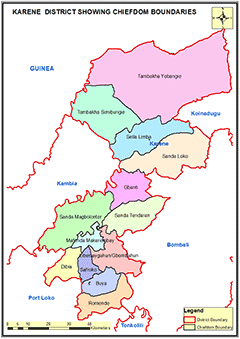
KARENE DISTRICT
Karene District is a newly created district in the North Western Province of Sierra Leone and the district headquarter town is Kamakwe. It was initially part of the Bombali District
Chiefdoms: The district is made up of (12) twelve chiefdoms: Tambakha Simibungie,Tambakha Yobangie, Gbanti, Libeisaygahun Gombagu, Mafonda, Makerembay, Sanda Tendaren, Sanda Magbolontor, Sella Limba, Buya, Romende, Safroko, Dibia.
Councils: Karene district council is headed by a Chairperson and assisted by a deputy chairperson. The District Council has 21 elected Councillors and 21 Wards. The wards in the Karene District ranges from Ward 212 to 232.
Constituencies: Karene District has 5 Constituencies represented by members of Parliament ranging from Constituency 63 – 67.
Ethnicity: The population of Karene district is predominantly from the Limba, Temne, Susu and Loko ethnic groups.
Economic Activities: The main economic activities in the Karene district is in the Agricultural Sector. Farming activities such as rice and cassava cultivation, cashew and ground nut, livestock, and fishing. Mining mineral resources is also another activity in the district. These mineral resources include; rutile, gold, aluminium, bauxite and diamond.
Education: Karene district has 364 schools; 16 pre-primary schools; 283 primary schools; 52 Junior Secondary Schools and 13 Senior Secondary Schools.
Population:
Name |
Status |
Population
Census
2004 |
Population
Census
2015 |
Population
census
2021 |
Karene |
District |
|
285,546 |
290,313 |
KARENE DISTRICT MAP SHOWING CHIEFDOM BOUNDARIES
COUNCIL HEAD |
Abdul Kandeh Turay
Chairperson
Karene District Council
Chief Administrator:
+23276767589
|
|