|
 |
KOINADUGU DISTRICT
Koinadugu District is a district in the Northern Province of Sierra Leone and one of the largest district in terms geographical area, but also one of the least populated. The district headquarter town is Kabala. Koinadugu district borders with Bombali on the west, Tonkolili District to the south-west, Kono District to the south, Falaba District to the east, and the Republic of Guinea to northeast.
Councils: The Koinadugu District Council is headed by a chairperson and assisted by a deputy chairperson. The Council has 18 elected Councillors and 18 Wards. The wards in the Koinadugu District ranges from Ward 142 to 159.
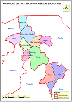
Chiefdoms: The district is made up of eleven (11) chiefdoms administered by Paramount Chiefs:Wara-Wara Bafodia, Kamukeh,Sengbe,Wara-Wara Yagalla, Diang, Kasunko-Kakellay, Gbongobor-Kayaka, Thamiso, Neini, Kallian, Barawa-Wolley.
Constituencies: Koinadugu District has 4 constituencies represented by members of Parliament ranging from Constituency 043 to 046 respectively.
Ethnicity: The population of Koinadugu district is diverse and the five main ethnic groups are: Kuranko, Mandingo, Fula, Limba, and Yalunka.
Economic Activities: Vegetable farming, rice cultivation, livestock and gold mining are the main economic activities in Koinadugu district. Timber Logging is becoming prominent in the past few years.
Education: Koinadugu district has 326 schools;29 pre-primary schools; 248 primary schools; 39 Junior Secondary Schools and 10 Senior Secondary Schools.
Population:
Name |
Status |
Population
Census
2004 |
Population
Census
2015 |
Population
census
2021 |
Koinadugu |
District |
135,005 |
204,019 |
206,133 |
KOINADUGU DISTRICT MAP SHOWING CHIEFDOM BOUDARIES

COUNCIL HEAD |
Lawrence Kargboo
Chairperson
Koinadugu District Council
Chief Administrator:
+23276768740 |
|
