MOYAMBA DISTRICT
Moyamba District is in the southern region and borders the Atlantic Ocean in the west, Port Loko District and Tonkolili District to the north, Bo District to the east and Bonthe District to the south. The district headquarter town is Moyamba town.
Councils: The Moyamba District council is headed by a Chairperson and assisted by a deputy chairperson. Moyamba District has 22 elected councillors heading the 22 ward committees ranging from Ward 327 to 348.
Constituencies: Moyamba District has 6 Constituencies ranging from Constituency 093 to 098
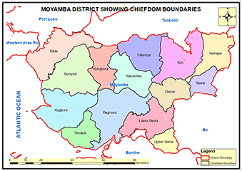
Chiefdoms: There are 14 Chiefdoms in Moyamba district administrated by Paramount Chiefs:Bagruwa; Banta; Bumpe; Dasse; Fakunya; Kagboro; Kaiyamba; Kamajei; Kongbora; Kori; Kowa; Ribbi; Timdale; Upper Banta.
Ethnicity: Moyamba District is one of the most ethnically diverse districts in Sierra Leone. The Mendes are the largest ethnic group in the district but the other minority tribes are the Themne, Fullah, Sherbro, Kissi, Mandingo and Kuranko collectively accounts for almost 50% of the district population.
Economic Activities: The main economic activities in Moyamba are Mining (rutile and bauxite), fishing, rice farrming and oil palm plantations.
Education: Moyamba District has 636 Schools; 33 Pre-primary Schools; 503 Primary Schools; 73 Junior Secondary Schools and 27 Senior Secondary schools. Moyamba District has one University (Njala university).
Population:
Name |
Status |
Population
Census
2004 |
Population
Census
2015 |
Population
census
2021 |
Moyamba |
District |
260,910 |
318,588 |
346,771 |
MOYAMBA DISTRICT MAP SHOWING CHIEFDOM BOUNDARIES
COUNCIL HEAD |
Joseph Benedict Mbogba
Chairperson
Moyamba District Council
Chief Administrator:
+23276392770
|
|