KONO DISTRICT
Kono District is in the Eastern Province of Sierra Leone and Koidu City is the district headquarter town. Kono District borders with Kenema District, the Republic of Guinea, Koinadugu District and Kailahun District.
Councils: Kono District has 2 Local Councils, Kono District Council headed by a Chairperson and the Koidu New Sembehun City Council (KNSCC) headed by a Mayor. Kono District Council is comprised of 24 elected councillors and 24 ward committees, whilst KNSCC has 15 councillors and 3 (multi-member) ward committees. The wards in Kono range from Ward 073-099.
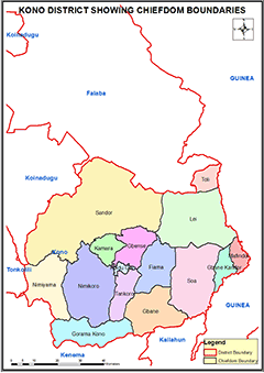
Chiefdoms: Kono District has 14 chiefdoms that are headed by Paramount Chiefs: Fiama; Gbane Kandor; Gbane; Gbense; Gorama Kono; Kamara; Lei, Mafindor, Nimikoro; Nimiyama; Sandor; Soa; Tankoro; Toli;.
Ethnicity: Kono District is one of the most ethnically diverse Districts in Sierra Leone, with the Kono tribe being the majority and indigenes. However, there are large population of Fullahs, and Madingos especially in the district headquarter.
Constituencies: Kono District has 8 Constituencies ranging from constituency 022 to 030
Economic Activities: Kono District is the diamond bed but also produces Gold. The other economic activities in the districts are production of rice, coffee and cacao.
Education: Kono District has 823 Schools. 145 Pre-primary schools, 511 Primary Schools, 118 Junior Secondary Schools and 39 Senior Secondary Schools.
Population:
Name |
Status |
Population
Census
2004 |
Population
Census
2015 |
Population
census
2021 |
Kono |
District |
335,401 |
506,100 |
620,703 |
KONO DISTRICT MAP SHOWING CHIEFDOM BOUNDARIES
COUNCIL HEADS |
Komba Matthew Sam
Mayor
Kono New Sembehun City Council
Chief Administrator:
+23276424041
|
Augustine Sheku
Chairperson
Kono District Council
Chief Administrator:
+23276755030 |
|