|
 |
TONKOLILI DISTRICT
Tonkolili District is in the Northern Province of Sierra Leone and Magburaka is the district headquarter town. Tonkolili District borders with Bombali District to the northwest, Kono District to the east, Kenema District and Bo District to the southeast.
Councils: The Tonkolili District Council is headed by a Chairperson and assisted by a deputy chair. The Council has 29 elected Councillors and 29 Wards. The Wards in the Tonkolili District ranges from Ward 160 to 188.
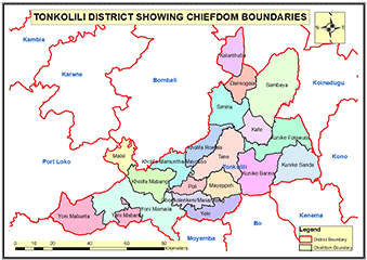
Chiefdoms: The Tonkolili District has 19 chiefdoms: Dansogoia, Kalantuba, Kafe, Simiria, Kholifa Rowala, Tane,Kunike Gbarnga, Kholifa Mayosso-Mamuntha, Kunike Sanda, Kunike Folawusu, Yele, Mayeppoh, Poli, Masakong,Yoni Mabanta,Yoni Mamailla, Kholifa Mabang, Malal, Sambaia
Constituencies: Tonkolili District has 10 constituencies represented by members of Parliament ranging from constituency 047 to 056.
Ethnicity: The Temne are the overwhelming majority in Tonkolili District.
Economic Activities: Mining of iron ore, bauxite, gold and to a lesser extent diamonds are the major economic activities in the Tonkolili district.
Education: Tonkolili District has 811 schools: 103 pre-primary schools; 578 primary schools; 101 Junior Secondary Schools and 29 Senior Secondary Schools.
Population:
Name |
Status |
Population
Census
2004 |
Population
Census
2015 |
Population
census
2021 |
Tonkolili |
District |
339,290 |
513,984 |
557,257 |
TONKOLILI DISTRICT MAP SHOWING CHIEFDOM BOUNDARIES
COUNCIL HEAD |
Yabom Sesay
Chairperson
Tonkolili District Council
Chief Administrator: Edward Alpha
+23278400102
|
|