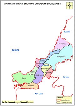
KAMBIA DISTRICT
Kambia District is in the Northern Province of Sierra Leone and the district headquarter town is Kambia. Kambia district borders the Republic of Guinea to the north, Port Loko district to the south and Bombali district to the east.
Councils: Kambia hosts the Kambia District Council which is headed by a Council Chairperson and 23 councillors who are heads of the 23 ward committees.
Chiefdoms: Kambia District has 10 Chiefdoms administered by Paramount Chiefs. These 10 Chiefdoms are as follows: Briama; Khonimakha; Gbinle; Dixing; Magbema; Mambolo; Masungbala; MunuThala; Samu; Tonko Limba
Economic Activities: The district is considered as the main rice bowl with large agricultural zone and extensive swamp areas in across the district. In addition, cassava, millet, sweet potatoes, sorghum, groundnuts and maize are planted in the district.
Ethnicity: The district is ethnically diversed, with ethnic such as Susu, Themne, Limba, Fullah and Mandingo being the most predominant.
Constituencies: Kambia District has 6 Constituencies ranging from Constituency 057 to 062
Education: Kambia district has 506 schools: 50 Pre-primary Schools; 352 Primary Schools; 77 Junior Secondary Schools and 27 Senior Secondary Schools.
Population:
Name |
Status |
Population
Census
2004 |
Population
Census
2015 |
Population
census
2021 |
Kambia |
District |
270,462 |
345,474 |
367,699 |
KAMBIA DISTRICT SHOWING CHIEFDOM BOUNDARIES
COUNCIL HEAD |
Mohamed Abdul Mansarico Mansaray
Chairperson
Kambia District Council
Chief Administrator
+23278811239
|
|